
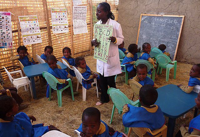
The education and skills development of a nation is crucial to its growth and development. Consequently, governments worldwide commission educational policy programs to ensure that their education systems are up-to-date and relevant. To go about this, education stakeholders need to conduct research that would provide insights that would shape decisions. This is where GIS comes into play.
Read Also: What is GIS? Understanding the Enterprise Technology Driving Change
In the intricate landscape of educational policy research, Geographic Information Systems (GIS) have emerged as a transformative force. It harnesses the power of spatial data and advanced mapping techniques, thereby empowering policymakers to gain unprecedented insights into the multifaceted dimensions of education. But what is the relationship between GIS and educational policy research? Let’s dive in.
Contents
Understanding GIS in Educational Policy Research
Geographic Information Systems (GIS) are sophisticated tools and technologies designed to capture, store, and analyze spatial or geographic data. At its core, GIS integrates data like maps, satellite imagery, and geographical features to visualize and interpret information. It enables the creation of interactive maps and provides powerful analytical capabilities, thereby offering insights into relationships, patterns, and trends.
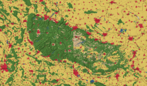
The utility of GIS in educational policy research is grounded in the recognition that education is inherently spatial and dynamic. GIS provides a powerful analytical framework for understanding the geographic dimensions of educational challenges and opportunities. By mapping out school locations, student demographics, and socioeconomic factors, it unveils spatial patterns that may not be immediately apparent through traditional data analysis methods. Therefore, this spatial perspective enables researchers and policymakers to identify disparities in educational access and optimize resource allocation.
Read Also: How GIS Helps Project Managers with Project Planning and Execution
How GIS Aids Educational Policy Research
1. It Provides Spatial Analysis of Educational Access
Socially excluded communities tend to be historically disadvantaged as far as access to education is concerned. Even when resources are provided, a lack of data can lead to underfunding, thereby creating even greater inequality. Therefore, policy-makers need tools such as GIS to provide insights that shape decisions. Researchers can leverage GIS to map school locations, student demographics, and existing transportation infrastructure. Through this comprehensive approach, they can pinpoint areas with limited access to educational resources, shedding light on the spatial inequalities that might exist. This information therefore helps eliminate disparities and ensure education equity.
2. Optimizing School Planning and Resource Allocation
Educational policy decisions rely heavily on efficient school planning and resource allocation. You need accurate data to help make informed decisions on planning. This is where GIS shines. It facilitates the optimization of school locations by providing spatial and geographic information. This therefore helps policymakers determine the most strategic placement of new schools based on demographic trends, population density, and future growth projections. Ultimately, it promotes equity in the distribution of educational resources.
3. Analyzing Socioeconomic Disparities
Education inequality is sadly the reality of our lives. For the most part, this is due to socioeconomic factors that befall marginalized communities. These disparities are difficult to map without efficient mapping tools. Consequently, GIS enables researchers to overlay educational data with socioeconomic indicators such as income levels. This integration allows for a comprehensive analysis of the socioeconomic factors influencing educational outcomes. Policymakers can then use this information to design targeted interventions and support programs for disadvantaged communities.
Read Also: How Corporate Training Promotes DEI in the Workplace
4. Mapping Student Demographics

In the pursuit of inclusive education, education stakeholders play a pivotal role in mapping the demographics of learner-teacher populations. Mapping the demographic composition of student populations is crucial for crafting inclusive education policies. GIS is uniquely suited for this undertaking. It can map specific demographics like ethnicity, language proficiency, and socioeconomic status. This information assists policymakers in tailoring educational initiatives to meet the specific needs of different student demographics.
5. Transportation Planning for Student Accessibility
Education policyholders usually take into consideration the relationship between learning centers and residences. This is because the distance between them can affect the delivery of education to learners. Therefore, they need tools that can help them map this information and provide actionable insights. Such a tool might just be GIS. It optimizes transportation routes, especially in large or geographically diverse school districts. These insights can help policymakers design efficient transportation plans. Consequently, this ensures that all students, regardless of their geographic location, have seamless access to educational opportunities.
6. Facilitating Data-Driven Decision Making
According to Forbes, data is crucial in driving decisions that have an impact not just on organizations but also on communities. GIS provides spatial and geographic data that can help drive impact decisions. Educational policymakers can visualize complex data sets through interactive maps, thereby gaining insights into patterns, trends, and relationships. Ultimately, this facilitates better informed and evidence-based decision-making processes.
Key Take-Aways
As educational policy researchers navigate the challenges of the 21st century, GIS emerges as an indispensable ally, providing actionable insights and guiding evidence-based decision-making. From unraveling spatial inequalities to optimizing resource allocation, GIS stands at the forefront of shaping a more equitable and accessible educational future. As technology continues to advance, the integration of GIS in educational policy research is poised to play an increasingly vital role in sculpting the educational landscape for generations to come. In essence, GIS is not just mapping the present state of education; it is charting the course for its future.
With the ever-growing need for effective educational policy research, investing in GIS training is an investment in a more sustainable future for our planet. Indepth Research Institute (IRES) offers comprehensive corporate training programs that would help you harness the power of GIS for effective education outcomes. Our training programs are specially curated and tailor-made to meet your needs, requirements and challenges. Register now and be the best version of yourself!
I’m a passionate communications professional with a flair for crafting compelling brand stories and driving impactful communications and marketing campaigns. With a background in public relations (PR) and marketing, I help shape narratives in today’s fast-paced digital landscape.


Comment here